Centre de Recherches Atmosphériques
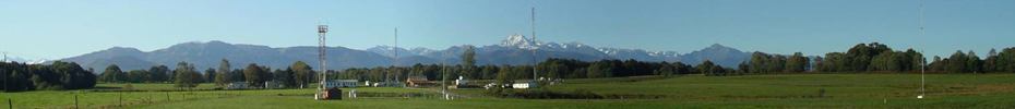
The « Centre de Recherches Atmosphériques » (CRA, 43,124184°N, 0.362576°E, 600 m asl) is a rural observatory for atmospheric sciences in Southwest France. Together with the CRA (http://icos-atc.lsce.ipsl.fr/cra), the Pic du Midi is part of the Pyrenean Platform for the Observation of the Atmosphere (P2OA, http://p2oa.aero.obs-mip.fr). The site is located on a relatively flat small plateau in the northern foothills of the Pyrénées, about 28 km north-east of the Pic du Midi. The closest Pyrenean valley exit is 10 km just south of the site (Aure valley), and the influence of the valley drainage flow is frequent at night. The CRA is inserted in a rural area, with mostly crops, prairies, forests, and small villages in the area. The site itself extends over 70 ha of pasture prairies. The CRA is located halfway (200 km) between the Mediterranean Sea and the Atlantic Ocean (Bay of Biscay), and close to the Spanish border (less than 50 km). The observatory is most often exposed to oceanic westerlies or northwesterlies. However, advection of continental air from the Iberian Peninsula flowing over the Pyrenees is not rare in south foehn conditions, which occur mostly ahead of fronts coming from the Atlantic Ocean especially in spring and autumn. The P2OA may occasionally be influenced by easterly Mediterranean flow, when mesoscale low pressure systems form over the Mediterranean Sea. The CRA is located away from major urban or industry areas. The nearest cities are Lannemezan (2 km east, 6,000 inhabitants), Tarbes (24 km north-west, 110,000 inhab.) and Pau (63 km west-north-west, 217,000 inhab.). Outside of these cities, countryside and mountain areas are sparsely inhabited. A moderate-traffic highway (about 25,000 all-type vehicles per day) bypasses the site to the south and the west, at a nearest distance of 2.6 km. Beyond ICOS measurements (carbon dioxide, methane, carbon monoxide, water vapor) at 3 levels (5, 30 and 60 m) of the tall instrumented mast, meteorological and energy flux measurements are conducted at 5 levels. Other permanent measurements are made on site, including 2 radars (UHF and VHF) measuring wind profile from 150 m to 16 km agl, a sky camera, and a ceilometer (http://p2oa.aero.obs-mip.fr/spip.php?rubrique2 ; http://www.aero.obs-mip.fr/observation/p2oa).

Quick access:
Instrument id: 810

MET