
| ICOS Atmosphere network map legend | ||
|---|---|---|
Step 1 validated (faded red star)  |
Step 2 entered (red star)  |
Labeled ICOS Atmospheric Stations (green star)  |
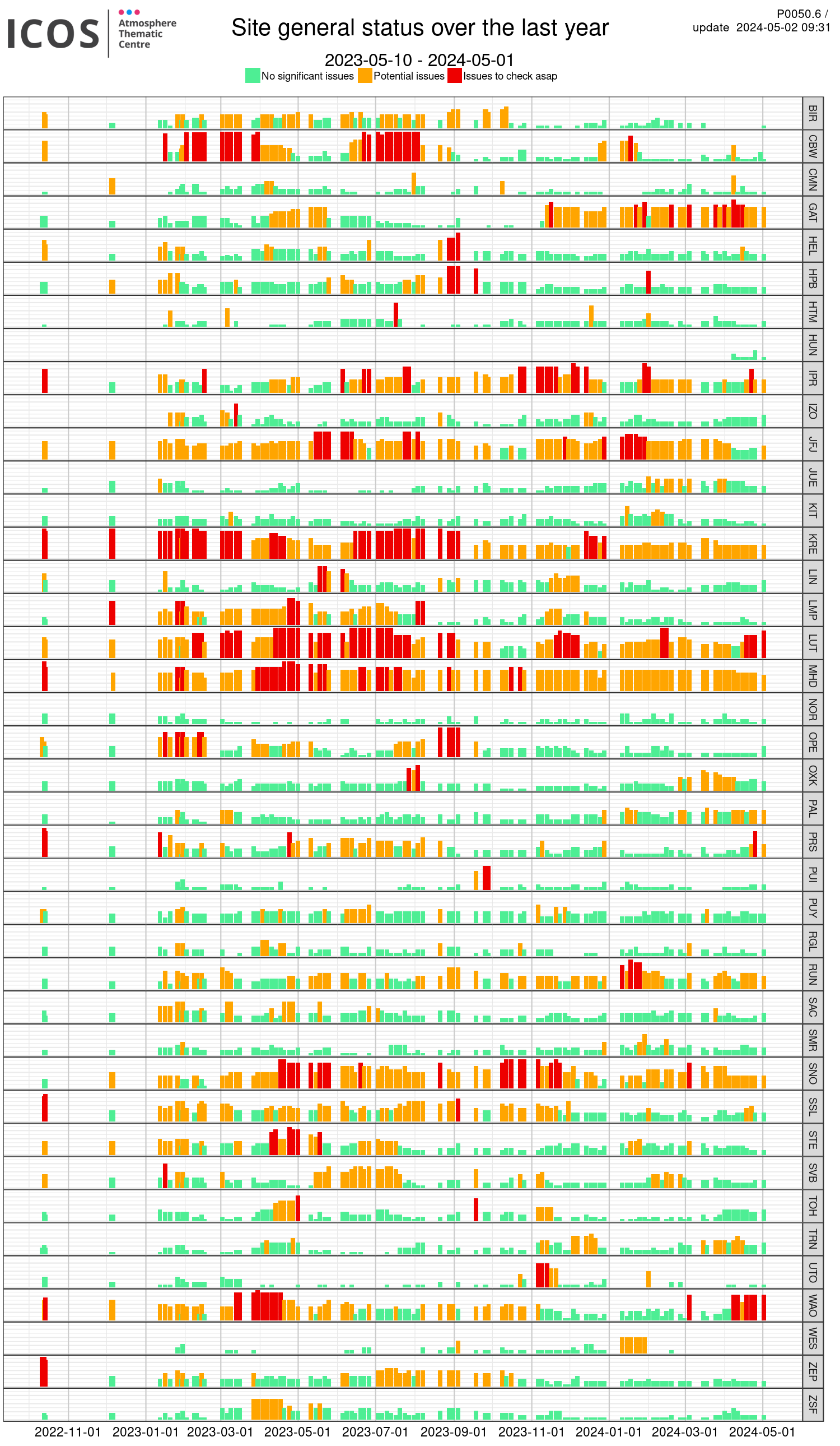
Click an ICOS atmospheric station to get information and direct access to selected station Panel Board, and see ICOS NRT data products.
Red marker is for stations entered in step 2 labelling process and faded red is for step 1. The ATC default output data files are evolving, they will contain a small metadata section before the columns description line. For more details see this page.
| Trigram | Latitude | Longitude |
|---|---|---|
| BIR | 58.388 | 8.252 |
| CBW | 51.970278 | 4.926389 |
| CMN | 44.193611 | 10.699999 |
| GAT | 53.0657 | 11.4429 |
| HEL | 54.1804 | 7.88328 |
| HPB | 47.8011 | 11.0246 |
| HTM | 56.0978042 | 13.4179573 |
| IPR | 45.8147 | 8.636 |
| JFJ | 46.55 | 7.9833 |
| JUE | 50.9284739 | 6.219629 |
| KIT | 49.0157644 | 8.2698423 |
| KRE | 49.5724533 | 15.0800322 |
| LIN | 52.1663 | 14.1226 |
| LMP | 35.518 | 12.6305 |
| LUT | 53.4036 | 6.3528 |
| NOR | 60.0821688 | 17.4594662 |
| OPE | 48.55 | 5.5 |
| OXK | 50.030031 | 11.80855 |
| PRS | 45.935 | 7.707 |
| PUI | 62.90944 | 27.65528 |
| PUY | 45.7719 | 2.9658 |
| RGL | 51.9974 | -2.5398 |
| RUN | -21.0796 | 55.3841 |
| SAC | 48.7227 | 2.142 |
| SMR | 61.8474 | 24.2947 |
| SNO | 81.36054 | -16.39432 |
| SSL | 47.9137 | 7.90787 |
| TOH | 51.801594 | 10.532392 |
| TRN | 47.964722 | 2.1125 |
| UTO | 59.7839 | 21.36717 |
| STE | 53.043081 | 8.458761 |
| SVB | 64.2354207 | 19.4295113 |
| ZEP | 78.9237424 | 11.834512 |
| WAO | 52.9506 | 1.1219 |
| ZSF | 47.42 | 10.98 |